
Physical map of Croatia, Slavonia and Dalmatia
|
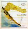
Vienna Karlo Herdliczka 1878 Paper, coloured lithograph 56 x 56.5 cm Map of the Triune Kingdom of Croatia, Slavonia and Dalmatia, with the Triune coat of arms and marked border of the territory with which the Kingdom entered the Kingdom of Serbs, Croats and Slovenes in 1919. A. Pandzic, Granice Hrvatske na zemljovidima od XII. do XX. stoljeca, (exhibition catalogue), Zagreb, 1992, page 123, catalogue number 73 |
|
HPM/PMH-032191 |


 |